



ASV Obstacle Avoidance: How It Works
ASV object detection is how a crewless boat spots ships, debris and shallow water, even at night or in fog, and changes course on its own in time. Read more.
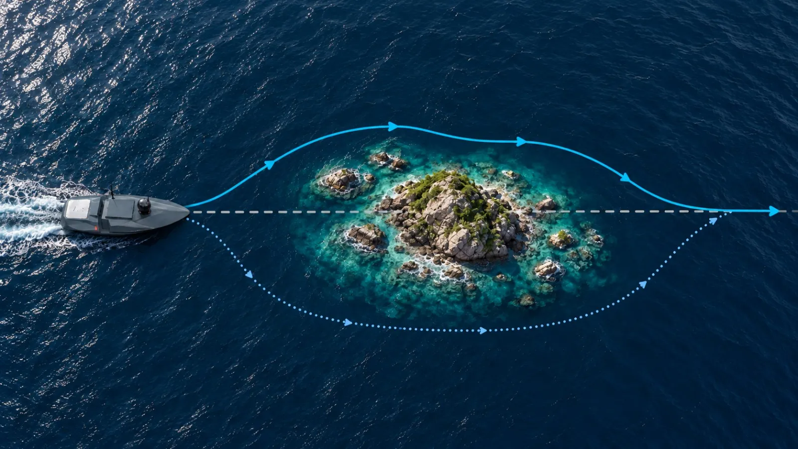
ASV obstacle avoidance is the ability of an autonomous surface vessel to detect boats, debris and shallow water around it, judge the risk of collision, and change its course or speed on its own before returning to its planned route.
What is an ASV, and how is it different from a USV?
An unmanned surface vehicle (USV) is any boat that works without people on board. Some USVs are driven by a pilot with a remote control. Others are partly or fully automated.
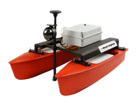
An autonomous surface vessel (ASV) is a type of USV. It follows a mission that the team plans in advance, such as a set of survey lines or patrol points, and makes its own decisions along the way. One of the most important is how to avoid obstacles. That is what ASV obstacle avoidance means, and it is the focus of this article.
So every ASV is a USV, but not every USV is an ASV. For a full introduction, read our guide to autonomous surface vehicles. To see how surface vessels compare with underwater robots, read our guide to ROV vs USV.
What ASVs are used for today
Common uses include:
- Hydrographic and bathymetric surveys of rivers, reservoirs, ports and the sea.
- Coastal and harbour monitoring with onboard cameras.
- Environmental monitoring, such as measuring water temperature and salinity.
- Carrying and launching equipment, such as an ROV.
- Defence and security work, such as patrols and support for mine countermeasure operations.
Each of these jobs depends on the ASV moving safely through water that it shares with boats, debris and changing weather.
The obstacles an ASV faces on the water
An ASV meets two kinds of obstacles. The first are physical objects: boats, buoys, floating debris such as logs and plastic, weeds, fishing nets, the shoreline and shallow water. Some stay in one place. Others move.
The second are the conditions of the water itself. Wind, currents, tides and waves do not block the way like a boat does, but they push the ASV away from its planned path all the time.
Why avoiding obstacles is harder on water
A car can brake and stop within a few metres. A drone can stop and hover in the air. A boat can do neither.
An ASV has no brakes. To slow down, it must cut power or reverse its thrusters, and its own weight still keeps it moving forward for some distance. Turning also takes time and space. A side current or a strong wind can push it sideways while it turns.
Without obstacle avoidance, an ASV would keep heading towards anything in its path. A collision can damage the ASV, its equipment and the other vessel, and stop the mission. A person would have to watch the screen for the whole mission, ready to take control, which removes much of the benefit of an autonomous vessel. So an ASV has to spot obstacles early and plan its moves well before it gets close.
How an ASV detects obstacles
An ASV uses sensors to know what is around it. Each sensor sees the world in a different way, and each has its own limits.
Radar: seeing far
A marine radar sends out short pulses of radio waves from an antenna that rotates through 360 degrees. The time each echo takes to return tells the radar how far away an object is, and the direction of the antenna gives its bearing. By comparing one sweep with the next, the system works out how fast a target is moving and in which direction.
Radar can detect ships and coastlines from several kilometres away, at night and in fog. It is less reliable for very small objects close to the vessel, and waves can add clutter.
LiDAR: seeing shapes up close
LiDAR works like radar, but it uses laser light. It sends out thousands of pulses every second and builds a detailed 3D picture of nearby objects, called a point cloud. It shows small objects that radar might miss, but its range is shorter, from tens of metres up to around 200 metres depending on the model. Heavy rain, fog and spray reduce how well it works.
Cameras: confirming and recording
Cameras help confirm what an object is, for example whether a shape on the radar is a boat, a buoy or a floating log. Thermal cameras detect heat, so they can spot boats and people at night, when normal cameras struggle.
Sonar: looking below the surface
Rocks, sandbanks and sunken objects need sonar. A forward-looking sonar warns of hazards ahead, and a multibeam echosounder maps the seabed below and around the vessel, which also helps it stay out of shallow water. Read more in our guide to sonar scanning.
Putting the sensors together
No single sensor works well in every condition, so ASVs combine them. This is called sensor fusion. The software compares what each sensor reports and builds one shared picture. If the radar picks up a target far away, the camera and LiDAR can confirm what it is as the ASV gets closer.
How an ASV changes course on its own
Before the mission: planning the route
The team sets the route as a series of waypoints, or as survey lines for mapping work. They can also draw no-go zones, called geofences, around shallow water or restricted areas. During the mission, the ASV uses satellite positioning (GNSS) to follow this plan.
Detect and track
The ASV checks its sensors many times every second. When an object appears, the system tracks its position, and if it is moving, its speed and direction.
Judge the risk
The ASV’s autonomy software, often called the autonomy stack, predicts where both the ASV and the object will be over the next few seconds or minutes. If their paths will come too close, the ASV treats it as a collision risk. For moving vessels, the system can estimate metrics such as Closest Point of Approach (CPA) and Time to Closest Point of Approach (TCPA). These help determine not only whether another vessel may come too close, but also how soon the situation could become critical.
Change course
The autonomy stack can change the ASV’s direction, reduce its speed, or do both, while allowing for wind and current. A small floating object may need only a short safety distance. A large vessel needs a much wider margin.
When the ASV meets other vessels, well-designed systems try to follow the international collision rules at sea, known as COLREGs. For example, when two vessels meet head-on, each should turn to starboard so they pass port side to port side.
Path-planning algorithms do this work. Dijkstra’s algorithm uses a map of known obstacles and no-go zones to find the shortest safe route around them. BendyRuler works in real time, checking several possible directions and picking the one that avoids the obstacle while staying closest to the original route.
Return to the route
Once the area is clear, the ASV goes back to its planned route. On survey work, the system notes where it left the survey line, so the team can survey the missed part again if needed.
How floating objects affect an ASV
Floating objects can affect an ASV even without a full collision. Contact can slow it down or push it off its heading. Weeds, ropes and fishing nets cause the most trouble, because they can wrap around a propeller and reduce its thrust or stop it. The motors then draw more current to keep the same speed, which drains the battery and heats the motors. If the load gets too high, the ASV may slow down or stop to protect itself.
The autonomy stack is the first line of defence. Design features add protection when something still gets through:
- Thruster guards stop debris and ropes from reaching the blades.
- Line cutters near the propeller cut through nets and ropes before they wrap around it.
- Health monitoring tracks motor current and temperature, and alerts the operator when they rise.
Recording data along the way
While it avoids obstacles, the ASV keeps collecting data. It can carry payloads such as multibeam or single beam echosounders, CTD sensors, GNSS receivers and cameras. Our guide to multibeam bathymetry vs side scan sonar explains the difference between these sonar tools. The ASV also logs its route, speed, heading and every obstacle it avoids.
Why the operator still matters
Most ASVs work under supervised autonomy. An operator on shore or on a nearby boat watches the ASV’s position, video and alerts live, and can pause the mission, change the route or take manual control at any time. If the communication link drops, most ASVs hold position or return to a set point until it comes back.
Conclusion
Obstacle avoidance lets an ASV spot hazards, move around them and get back to work without a crew on board. That is what allows it to run surveys, monitor water conditions and support security work on its own.
Planning a survey or a research project? Talk to the EyeROV team about how an autonomous surface vessel could help.